A record dry January in some spots, with no precipitation currently on horizon for first half of February
Record dry January for portions of CA and NV (but thank goodness for “Bombtober”)
Well, I don’t need to tell most folks twice: January 2022 was an exceptionally dry month across most of California and Nevada. Some spots saw a bit of rain and snow during the first couple days of the month, but others saw nothing at all; the last 25 days of the month brought essentially zero precipitation to the entire region. As a result, January 2022 will go down in the record books as the driest January on record (since at least 1895) for most of the San Joaquin Valley, the Central and Southern Sierra, and pockets of the Sacramento Valley and western Nevada. Due to the clear and dry conditions, temperatures were (on average) warmer than usual for January, but with a wide diurnal spread: overnight minimum temperatures were actually slightly *colder* than usual, but daytime high temperatures were significantly above average (and, thus, won out on in the monthly average).
As a result of these exceptionally dry and also warmer than average conditions, mid-winter snowmelt has begun in the Sierra Nevada and vegetation even across parts of normally very damp NorCal has dried out to levels more typical for May or June. While that’s still not nearly as dry as it would be during summer or autumn–closer to the peak of fire season–there have been a handful of notable wildfires over the past month and this pattern could perhaps continue for as long as we continue to see near-zero precipitation and occasionally windy conditions this winter.
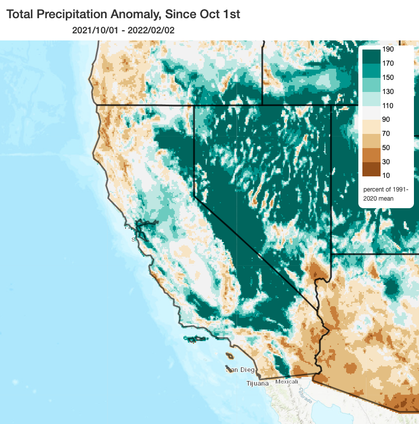
In this context, it is exceptionally fortunate that California received as much precipitation as it did early in the season. The much discussed “Bombtober” (the extreme atmospheric river event and record single-day precipitation event in NorCal brought about by the rapid strengthening, or “bombogenesis,” of an offshore storm in October) singularly made October 2021 the wettest October on record across most of NorCal. And while November was pretty dry, December was quite wet and cold–and brought prodigious mountain snowfall. Remarkably, however, statewide snowpack has plummeted from a remarkable 160% of average in late December to 87% of average as of this writing. Meanwhile, statewide average precipitation to date is still somewhat close to average for the date despite a record dry January thanks to the very wet Oct and Dec, though parts of the state have already burned through this substantial head start and more areas will start to be below average for the season to date over the next 2 (dry) weeks. Still, it remains the case that October and December’s precipitation totals have prevented the 2021-2022 Water Year from being catastrophically dry. I still think it’ll end up dry (perhaps very dry), and the drought will persist (and perhaps re-intensify) through the summer and fall to come. But the state would now be in dramatically worse shape were it not for that early season precipitation–a truly fortuitous stroke of luck.
Bone dry outlook for next 2 weeks continues; strong ridging and warmer temps dominate
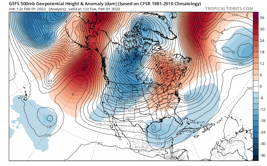
I don’t have a great deal of good news (or, really, anything new) to report regarding the outlook for the next 10-14 days (at least): it looks very dry and warmer than average essentially statewide. The reason? Well, it’s the same old story: an increasingly resilient ridge of high pressure keeps re-developing and re-strengthening just west of the West Coast, in a perfect position to deflect the Pacific storm track. This is, of course, a familiar refrain: it’s highly reminiscent of the Ridiculously Resilient Ridge pattern of recent years. While I’m not quite ready to pull the adverbial modifier trigger yet, we’re almost there if this thing persists through much of February (as appears likely).
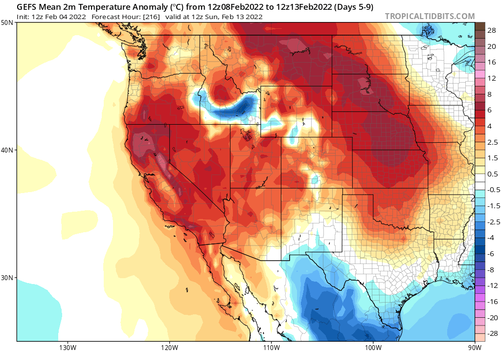
Mesmerizing/alarming animations aside, temperatures also appear likely to warm well above typical February levels by mid-month. In fact, temperatures in some spots could end up downright springlike for a week or so, with widespread 60s and 70s (maybe some 80s?) at lower elevations and even high mountain temperatures struggling to get much below freezing at night. That will probably accelerate snowmelt and soil drying nearly statewide (though will hopefully also offer some nice windows for prescribed fire, whenever the winds die down).
Odds of drier-than-average finish to wet season continue to be high
The just-released seasonal model ensemble outlooks continue to paint a very consistent picture regarding the rest of the “wet season:” the most likely outcome is continued drier than average conditions across most of California (and, indeed, most of the broader Southwest). The best chance of seeing some substantial precipitation and perhaps a bit more drought relief would be in the northern fifth of the state–so the North Coast and Shasta area stand better odds as we head toward March and April. Elsewhere, it is possible that a majority (perhaps a great majority) of the year’s precipitation has already occurred. There are some hints that March (or even late February) won’t be quite as bone dry as January and the first 3 weeks of February, and I would be pretty surprised by a total shutout during that period. But there are certainly no indications of a “Miracle March” at this point, absent a very unexpected development. So for now, I’ll keep my fingers crossed that we can squeeze out as much rain and snow in late Feb or March as possible–even if it’s not as much as most folks would like to see. Stay tuned.
